


Typical Relics of Quaternary Glacial Landforms found in Zhagana Mountains, Diebu County, Gansu Province, by Scientists from CAREERI,CAS
Updatetime:2010-04-21From:
【Enlarge】【Reduce】
Typical Relics of Quaternary Glacial Landforms found in Zhagana Mountains, Diebu County, Gansu Province, by Scientists from CAREERI,CAS
“A typicalformer glacier valley and a large numbers of glacial relics have been found inZhagana Mountain, Diebu County, Gansu Province, China”, said by Yongping Shen, a Quaternary geology professor from Cold and Arid Regions Environmental and Engineering Research Institute of Chinese Academy of Sciences in Lanzhou.
Zhagana Mountain with a highest peak of 3,970 m is located in Yiwa Village, Diebu County, Gansu Province and belongs to the Dieshan Mountains in southeast parts of Qinghai-Tibet Plateau.
Diebu region has rich in tourism resources with unique geological features, the vast rolling forests, beautiful mountains and wonderful scenery, and long history and culture, folk culture and religious culture of the Tibetan nation. Diebu County of the Gannan Tibetan Autonomous Prefecture boundaries to southern Gansu-Sichuan border, lying northwest to southeast, 110 km from east to west, 75 km from north to south, land area of 5,108.3 square kilometers,and has a population of 40000, mostly Tibetan nationality; 58% of its area is covered with forests; 17 minerals including uranium, dolomite, iron, gold, copper, antimony, etc. have been found; 27 wild animals including pandas, leopards, sika deer and some other rare animals live here.
Zhagana Mountain is one of concentration of the tourism resources, has beautiful scenery, great ornamental value as a unique karst landscape of peaks forest, caves landscape, fall water landscape ,and Quaternary glacial landforms with U-shaped glacial valley remains, hanging valleys, cirques, horn peaks group, edge ridge, drumlin, Roche mouton née landscape. Effective developing of tourism resources of the Quaternary glacial landforms will promote Diebu economic restructuring as soon as possible, pulling Diebu rapid economic growth, promoting Diebu economic, social, and environmental development, promotion Diebu harmonious society, said by Yongping Shen.
In high mountains of Diebu, there is glacial U-shape valley, cirque hanging valleys, fin ridges, glacial lakes, glacial polish landforms, indicating that there are former glacial activities in Quaternary period. The study of Quaternary glacial activity and global climate change remains a very important of the scientific value.
In high mountains of Zhagana area, there are a large amount of Quaternary glacier relics, with glacial landforms tourism value, and potential for the establishment of geological park of ancient glaciers. At present, raising the initial investigation and research, has found that cause of Zhaganaformer glacial landscapesis different, and provides a rich material in regional environmental research studies, landscape ecology and other aspects occupied an important position. Diebu is located on the edge of the Tibetan Plateau, the landscape processes and patterns of development recorded uplift of the plateau , especially the unique alpine karst landscapes and former glacial landscape features also has outstanding ornamental value. The Zhagana scenic area is located at 3,200 meters from the bottom of the scenic landscape, to around the glacial peak elevation of 4,300 meters, more than 1,000 meters of vertical difference, the formation of a diversified portfolio of natural vegetation and topography, valley areas inhabited by ethnic groups and residential areas, to provide the colorful ethnic customs and culture, and beauty of nature blend to form a variety of complex landscapes.
Glaciologists have early paid attention to glacier change during Quaternary period. Professors Shi Yafeng, Zheng Benxing and other scientistsfrom CAREERI, CAS, who had successfully done a plenty of research work on glacier dynamic changes in regions of west China, have provided lots of scientific evidences for studying time and space law of glacier change in China.
The Diebu County is preparing to turn the former glaciallandforms into a glacier geological park to preserve the relics and provide a research base for scientists. Glacier relics can also help us predict global climate trends, trace the beginning of global warming and predict possible global cooling in the future.

Figure 1, the News Conference, chaired by Zhang Xiaojun, the assistant director of Cold and Arid Regions Environmental and Engineering Research Institute of Chinese Academy of Sciences,jointly held by Diebu County People's Government of Gannan Prefecture, Gansu Province, Cold and Arid Regions Environmental and Engineering Research Institute of Chinese Academy of Sciences, and Gansu Qinghai-Tibet Tianlu Culture and Arts Co., Ltd. on 29March, 2010.
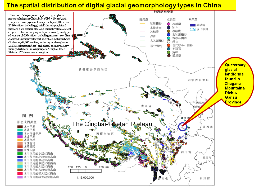
Figure 2, this map showing the location of Zhagana Quaternary glacier landforms
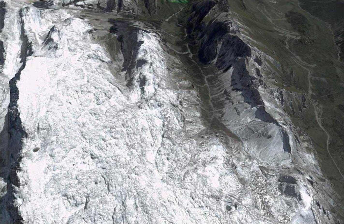
Figure 3, this picture show a landscape of former glacial erosion relics, U-shape valley, glacial lakes and cirques, and Karst sinkholes
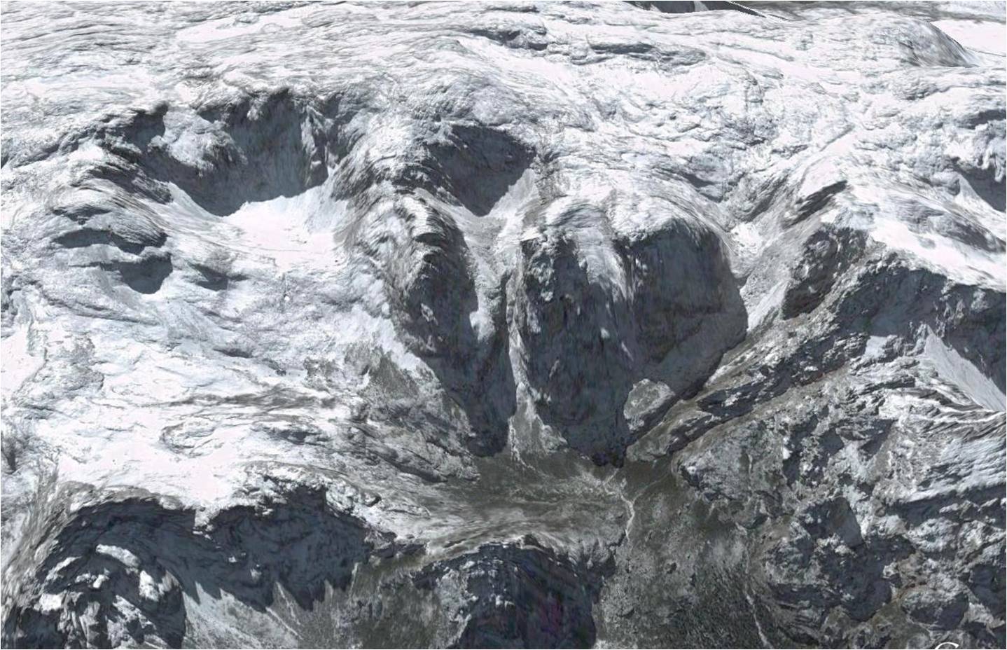
Figure4, this picture show a landscape of former cirques
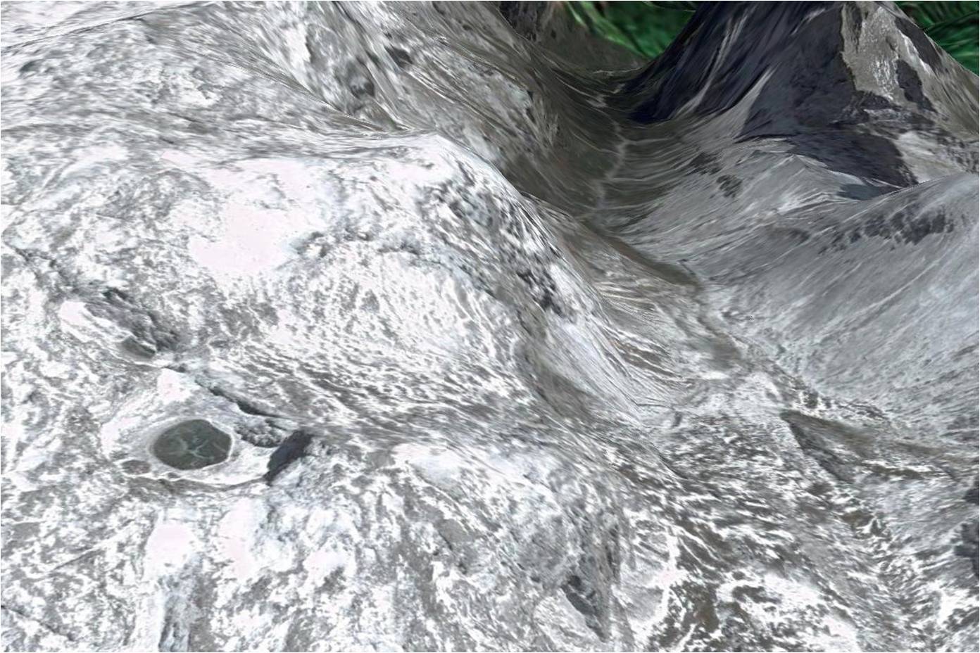
Figure5, this picture show a glacial U-shape valley landforms and a glacial erosion lake
Appendix
