


Glacial geomorphology and glacial history of the Muzart River valley,Tianshan Range, China
Updatetime:2011-03-17From:
【Enlarge】【Reduce】
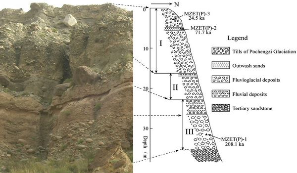
(A well-exposed section located about 200 m to the east of the abandoned Pochengzi coal mine)(image/Quaternary Science Reviews)
The research of glacial geomorphology and glacial history of the Muzart River valley,Tianshan Range was recently finished by the researcher of Cold and Arid Regions Environmental and Engineering Research Institute.This research has great significance to provide a new conceptual framework for Quaternary glaciations in this valley.
The Muzart River originates on the southeastern slope of Tumur Peak, the largest center of modern glaciation in the Tianshan Range. Glacial landforms and sediments indicate that there are four major
Quaternary glaciations in this drainage. The glacial landforms contain considerable information about the changes of the ancient glaciers. Dating the landforms allows the temporal and spatial variations of
the ancient glaciers in this valley to be understood and provides essential information in reconstructing the paleoenvironment in this region. Electron spin resonance (ESR) dating of a well-exposed section, the multiple end moraines of the Pochengzi glaciation (the third set of moraines), and the local outwash and fluvial sediments on the Kezibulake glacial plain (the fourth set of moraines) was carried out using germanium (Ge) centers in the glacial quartz grains, which are sensitive to both sunlight and grinding.Eleven depositional ages have been determined. Based on the dating results, the principle of superposition and the glaciations pattern reported in the adjacent valley, the Pochengzi end moraines were determined to be deposited during the major glacial intervals that are equivalent in age to marine oxygen isotope stages (MIS) 2, mid-MIS 3 and MIS 4 and the Kezibulake glacial deposits were determined to be equivalent in age to MIS 6. Furthermore, the Tugaibieliqi end moraine (the second set of moraines) was deposited during the Neoglaciation (a cold period between 3 and 4 ka) and the 3e4 end moraines located at the terminuses of the modern glacier were deposited during the Little Ice Age. The ages of the Pochengzi glacial deposits can be subdivided into three clusters, they are 13.6e25.3 ka, 39.5e40.4 ka and 64.2e71.7 ka, respectively. The largest local last glacial maximum (LGML) occurred during MIS 4 rather than the global Last Glacial Maximum (LGMG) of MIS 2. Furthermore, a glacier that is slightly larger than that of MIS 2 developed in this drainage during mid-MIS 3. The ancient Muzart glaciers were compound valley glaciers during the Neoglaciation, MIS 2 and mid-MIS 3, and piedmont glaciers during MIS 4 and MIS 6.
This research was supported by the National Natural Science Foundation of China (Nos. 40501007, 40772116, 40801031), National Basic S&T Project of Program (2006FY110200) and National Basic Research Program (2010CB833406) of the Ministry of Science and Technology of China.
Appendix
