Scientists Improve Gridded Precipitation Dataset for the Tibetan Plateau
Updatetime:2020-12-08From:
【Enlarge】【Reduce】
An accurate gridded precipitation dataset is essential for a better understanding of climate change, hydrological, and ecological processes on the Tibetan Plateau. However, the precipitation observation network in this region is so sparse. The observed precipitation is susceptible to complex meteorological and orographic conditions, limiting the accuracy of the gridded precipitation dataset. The variety of precipitation instruments in the Tibetan Plateau and surrounding areas has also seriously affected the correction of measured precipitation.
A team from the Northwest Institute of Eco-Environment and Resources (NIEER) of the Chinese Academy of Sciences (CAS) proposed a new precipitation dataset by compensating the precipitation undercatch from different kinds of instruments around the Tibetan Plateau and optimizing the precipitation frequency distribution in the interpolation scheme.
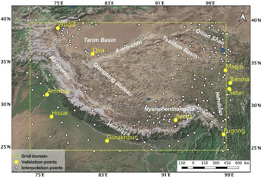
The dataset uses the observed precipitation of 159 stations as the data source (Fig. 1) and corrects the gauge undercatch. Then by comparing six commonly used interpolation schemes using precipitation frequency error as the evaluation standard, the optimal interpolation scheme suitable for The Tibetan Plateau is obtained. A set of daily gridded precipitation dataset with a spatial resolution of 10km from January 1, 1980 to December 31, 2009 is obtained based on those works.
The results show that undercatch correction is necessary for station data, which can reduce the distributional error by 30% at most. A thin-plate splines interpolation algorithm considering altitude as a covariate is helpful to reduce the statistical distributional error in general.
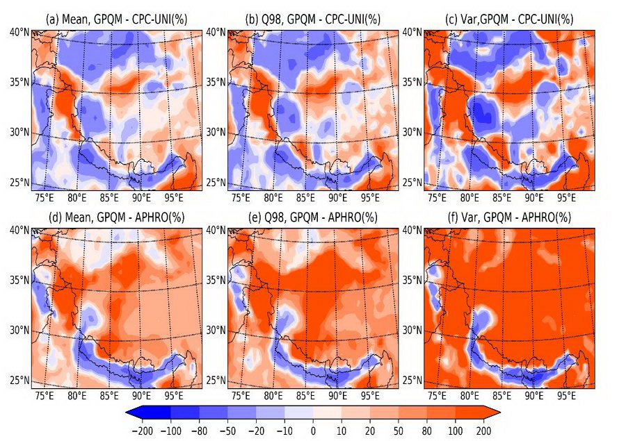
Compared with the existing gridded precipitation dataset, this dataset has better precipitation frequency distribution characteristics, a more reasonable mean value, variance, and a better suppressive smoothing effect widely existing in the previous gridded precipitation products (Fig. 2). The results provide a relatively reliable gridded precipitation dataset for those hydrometeorological studies on the Tibetan Plateau.
The dataset has been published online by the National Cryosphere Desert Data Center and the National Tibetan Plateau/Third Pole Environment Data Center. This job titled "Reducing the Statistical Distribution Error in Gridded Data for the Tibetan Plateau" was published in "Journal of Hydrometeorology." Ms. MA Jiapei and Prof. LI Hongyi are the first and corresponding author, respectively.
This job is supported by the Chinese Academy of Sciences through the Strategic Priority Research Program, the National Key Research and Development Program of China and the National Natural Science Foundation of China.

Figure 1 The study area and the distribution of observation sites. The ten yellow points represent the independent sites used for frequency distribution validation, and the white points represent the points for gridding. The yellow dotted rectangle is the interpolation extent. (Image by LI Hongyi)

Figure 2 The difference between the corrected results and the previous dataset. Mean is the daily average, Q98 is the 98th percentile, Var is the variance and APHRO means the APHRODITE dataset. All of the results consider only wet days, which are classified by a threshold of 0.1 mm/d. The first column (a, d) shows the difference in the daily average. The second column (b, e) shows the difference in the daily 98th percentile. The third column (c, f) shows the difference in the daily variance (Image by LI Hongyi)
Contact:
CAO Rui
E-mail: caorui@lzb.ac.cn
Northwest Institute of Eco-Environment and Resources, Chinese Academy of Sciences (CAS), Lanzhou 730000, China.
Appendix


