


Chinese Scientists to Create 3D Map of Glaciers on Mount Qomolangma, Share It Globally
Updatetime:2022-05-27From:
【Enlarge】【Reduce】
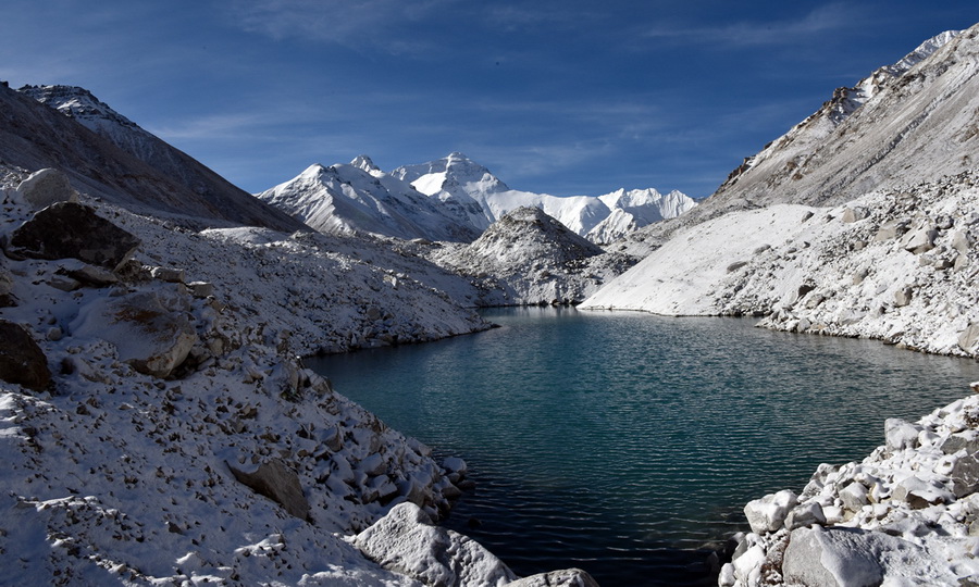
Rongbuk glaciers in the Mount Qomolangma region Photo: IC
As a month-long comprehensive scientific expedition to Mount Qomolangma, also known as Mount Everest, has drawn to an end, Chinese glaciologist Kang Shichang - who led a glacier and pollutant research group as part of the expedition - said that they will form a 3D digital map of the glaciers on Mount Qomolangma based on their field measurements, and the related research and data will be shared with international scientists.
Kang, who is deputy director of the Northwest Institute of Eco-Environment and Resources of the Chinese Academy of Sciences, told the Global Times that his research team scanned a record area of 22 square kilometers at the East, Middle and West Rongbuk glaciers in the Mount Qomolangma region using a drone and a high-precision 3D laser scanner from May 1 to 8.
Researchers will use the scanned data to form a high precision 3D map of the glaciers to understand their changes, compared with previous data.
Kang, who has visited the world's highest peak 11 times, said follow-up analysis and results will be published in academic journals and shared with international peers.
Kang's team also collected snow and ice samples at an altitude of 6,500 meters for research on the isotopes of mercury, sulfur and black carbon to understand the impact of pollutant emissions on the world's highest peak and the Qinghai-Xizang Plateau.
Kang said the impact of global human activities on the region can be observed through long-term monitoring and study of changes of glaciers and air pollutants.
Compared with solid pollutants, air pollutants - which may drop onto glaciers - are more likely to affect the environment of Mount Qomolangma, Kang said.
According to a study led by Kang on recent climate and environmental changes in the Mount Qomolangma region, the region has experienced significant warming since 1960, about 0.33 C per decade.
The researchers projected that the region will usually show a warming trend in the future (through 2099), and the warming rate in the winter will be greater than that in the summer.
The study, "Warming and thawing in the Mt. Everest region: A review of climate and environmental changes", was published in Earth-Science Reviews in February.
The study said that the glacier areas in the Mount Qomolangma region showed significant shrinkage from the 1970s to 2010. Glacier retreat has led to significant increasing of river runoff.
Due to the remote location of Mount Qomolangma and sparse human activity, the atmospheric environment is relatively clean. However, the researchers said that long-range transport of atmospheric pollutants from South Asia and West Asia may have substantially influenced the Mount Qomolangma region, resulting in increasing concentrations of pollutants since the Industrial Revolution.
Kang's group is part of a scientific research team consisting of more than 270 members from five teams in the comprehensive scientific expedition on Mount Qomolangma, which falls within China's second scientific research survey of the Qinghai-Xizang Plateau.
After leaving the Mount Qomolangma region, Kang's team visited several other glaciers in the Qinghai-Xizang Plateau to collect more snow and ice samples and maintain air pollutant monitoring sites along the route, including the Anglong glacier in Ali Prefecture in Southwest China's Xizang Autonomous Region and the Demula glacier. (Global Times)
Appendix
