Desert Dynamics Monitoring by RS and Its Driving Factors in Source Region of Yangtze River
Updatetime:2010-12-29From:
【Enlarge】【Reduce】
A RS database derived from Landsat MSS in middle 1970's, Landsat TM in 1990, Landsat ETM+ in 2000 and Landsat TM in 2005 was employed to analyze the desert sptio-temporal variation in source region of Yangtze River by GIS technique. The desert in study area was classified into six types: alpine desert, naked-rock desert, Gobi, sandy desert, bare land, and saline-alkaline land. Deserts cover the most area of source region of Yangtze River, occupying 28% of the total area. Alpine desert, naked-rock desert, Gobi, and sandy desert are dominant; bare land and saline-alkaline land are second. The evolution of desert developed positively from middle 1970's to 1990, with an increase by 43 935 hm2, adversely from 1990 to 2000 with a decrease by 32 821.28 hm2, again with an increase of 29 611.30 hm2 from 2000 to 2005.
|
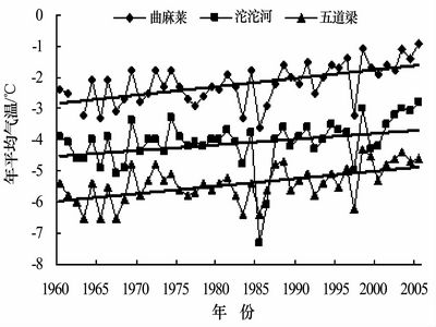
Variation of annual mean air temperature from 1960 to 2005 (Picture/Journal of Desert Research) |
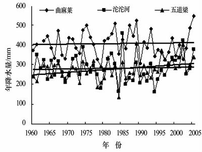
Variation of annual precipitation from 1960 to 2005 (Picture/Journal of Desert Research) |
Appendix


