Numerical Simulation of Local Circulation in Valley City in Winter Using RAMS Model
Updatetime:2010-12-29From:
【Enlarge】【Reduce】
The characteristics of local circulation in valley city were simulated using the mesoscale numerical model RAMS developed by Colorado State University and the MRC/ASTER and triple-nested simulation method. The results are as follows: (1) Wind direction near the ground of the Lanzhou city is main from east to west, and the wind speed is relatively larger more in the narrow area between the eastern and western city. In the eastern and western center of the valley city have large areas of the static wind zone; near the surface wind in the valley city of Lanzhou is convergence in the winter night, and during the day is a divergence flow. By the effect of the urban heat island circulation, the daytime heat island circulation inhibiting the valley breeze circulation, increased night-time mountain breeze circulation, and the velocity of the mountain breeze at night is larger than the velocity of the valley breeze in the daytime. (2)During the day, there is downdraft above the Lanzhou city and the valley between the mountains. It′s mainly due to the terrain effect and the heating effect of mountain peak. At night, there is updraft above the Lanzhou city and the valley between the mountains. It′s mainly due to the terrain effect which makes mountain breeze circulation in the night, while there is strong inverse temperature in exist above the Lanzhou city and the valley between mountains which restrain the updraft of the air in the winter night. (3) Around the divergence gradually weakened from the near surface to 400 m heights above the Lanzhou city, then it turned into convergence at the heights of 510 m; the convergence gradually weakened from the near surface to 400 m heights above the Gaolan mountain, then it turned into divergence at the heights of 510 m. Around 01:00, the convergence gradually weakened from the near surface to 400 m heights above the Lanzhou city and was strongest at the height of 400 m, and then it gradually weakened from 400m to 510 m heights; the divergence gradually weakened from the near surface to 220 m height, then it turned into convergence at the heights of 400 m. The convergence gradually enhanced from 400 to 510 m heights above Gaolan mountain.
|
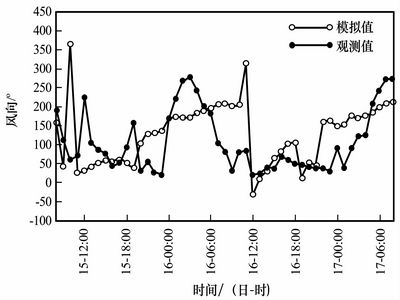
Comparison of the simulated horizontal wind direction and the observed value (Picture/Plateau Meteorology) |
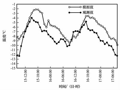
Comparison of the simulated near surface temperature and the observed value (Picture/Plateau Meteorology) |
Appendix


