Modeling of Spatiotemporal Distribution of Groundwater Level in Water Table Fluctuant Belt of the Lower Heihe River Reaches
Updatetime:2011-01-21From:
【Enlarge】【Reduce】
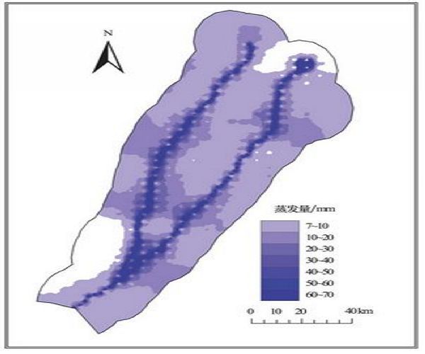
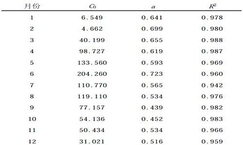
There is little precipitation in the lower reaches of Heihe River . The groundwater level determines the pattern and distribution of vegetation , a highly valuable resource to animals and with important role in eco-environment . Based on the field investigation of geology and hydrogeology , a three-dimensional aquifer system (45312 cells and 3 slices) was constructed. Evaporation of groundwater is a key outlet which drops the groundwater level . The relationship between the groundwater level and groundwate revaporation was built as : E = C0 e -aD . The spatial distribution of the initial groundwater level was obtained by interpolation , and then the initial spatial distribution of evaporation was calculated according to their relationship .The study lays a foundation for modeling spatial and temporal distribution of t he groundwater level in the study area .
|
Spatial distribution of groundwater evaporation in initial stage (Picture/Journal of Desert Research) |
|
Parameters for calculating groundwater evaporation capacity in different month (Picture/Journal of Desert Research) |
Appendix


