


Reservoir Capacity Calculation and Variation of Moraine-dammed Lakes in the North Himalayas
Updatetime:2011-03-23From:
【Enlarge】【Reduce】
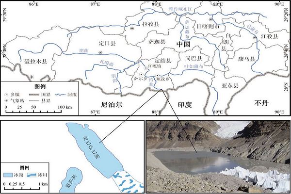
(The Location of Longbasaba Lake) (image/ACTA GEOGRAPHICA SINICA)
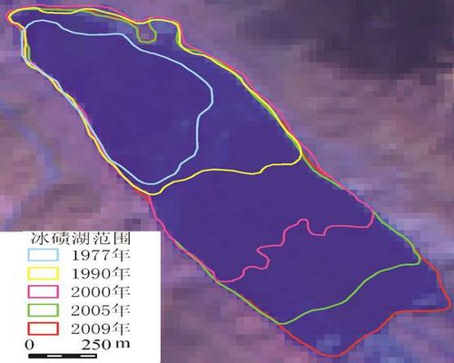
(Variation of Longbasaba Lake from 1977 to 2009) (image/ACTA GEOGRAPHICA SINICA)
The research of Reservoir Capacity Calculation and Variation of Moraine-dammed Lakes in the North Himalayas was finished recently by the researcher of Cold and Arid Regions Environmental and Engineering Research Institute.The accomplishment of the research has the important significance to provide the theoretical reference for calculating the reservoir capacity of other moraine-dammed lakes
in the Himalayan region.
Glacial Lake Outburst Flood (GLOF) hazards were paid more attention in Himalayan region. The accurate calculation of reservoir capacity of glacial lake is very important for estimating outburst flood peak discharge and simulating flood evolution. The Longbasaba Lake, located in Dingjie County of Tibet, is a potential dangerous moraine-dammed lake. Its depth was measured by HydroboxTM high resolution echo sounder and 6916 samples were collected in field investigation held in September 2009. The maximum depth and average depth of Longbasaba Lake were found to be up to 101.94 m and 47.50 m, respectively. Based on the same time Landsat Thematic Mapper (TM) image interpretation, lake basin shape was simulated by constructing Triangulated Irregular Network (TIN) and the reservoir capacity was 0.64 × 10⁸ m3. Furthermore, multi-source remote sensing images from 1977 to 2008, such as Landsat MSS, topographic map, Landsat TM and ASTER, were interpreted and digitalized by a
GIS software. The result showed that the length and area of Longbasaba Lake were increasing in the last 32 years and the tendency was more significant since 2000. The empirical formula of volume-area of moraine-dammed lake was built by analyzing the volume and area in different periods, which could be used to calculate the reservoir capacity of other moraine-dammed lakes in the Himalayan region. The follows is the formula:
V = 0.0493A0.9304 n = 15
R2= 0.9903 α= 0.01。
Also,based on the analysis of the interdecadal variations in temperature and precipitation from five weather stations in this region, and the same direction of lake expansion with the glacier recession, it could be demonstrated that the area increase of Longbasaba Lake was due to climate warming, glacier ablation and retreat.
The research was subsidized by the National Natural Science Foundation of China (Grant no. 40801025; 41071044).
Appendix
