An integrated analysis approach to LUCC at regional scale:A case study in the Ganzhou District of Zhangye City,China
Updatetime:2012-12-31From:
【Enlarge】【Reduce】
Land use/cover change (LUCC) models are helpful tools for analyzing driving forces and processes of land use changes, assessing ecological impacts of land use change and decision-making for land use planning. However, no single model is able to capture all the essential key processes to explore land use change at different spatial-temporal scales and make a full assessment of driving factors and macro-ecological impacts. Taken Ganzhou District as a case study, this research describes an integrated analysis (IA) approach by combining with system dynamics (SD) model, the Conversion of Land Use and its Effects at Small regional extent (CLUE-S) model and landscape indices method to analyze land use dynamics at different spatial-temporal scales. The SD model was used to calculate and predict demands for different land use types at the macro-scale as a whole during 2000–2035. The LUCC process was simulated at a high spatial resolution with the spatial consideration of land use spatial policies and restrictions to satisfy the balance between land use demand and supply by using the CLUE-S model, and Kappa values of the map simulation are 0.86 and 0.81 in 2000 and 2005, respectively. The researchers evaluated the macro-ecological effect of LUCC and optimized scenario managements of land use by using landscape indices method. The IA approach could be used for better understanding the complexity of land use change and provide scientific support for land use planning and management, and the simulation results also could be used as a source data for scenario analysis of different hydrological and ecological processes based on different underlying surface of LUCC.
This research developed an IA approach to understand the characterization and presentation of LUCC processes by combining CLUE-S, SD and landscape indices methods,which gave insight into better understanding of the possible impacts of LUCC on terrestrial ecosystems and provided scientific support for land use planning and scenario management.This IA approach can be applied in other similar study areas. The simulation results also could be used as a source data for scenario analysis of different hydrological and ecological processes based on different underlying surface of LUCC.
The successful application of the IA approach in Ganzhou District proves that the integration of current existing models and approaches based on the multi-scale characteristics of LUCC within a single modeling framework could be a feasible solution, because it is able to reflect the complexity of the land use system and capture key processes of land use change at different scales. Furthermore, the identification and spatialization of key driving factors (especially human factors, such as social capital, cultural types) of LUCC is an important issue, and integrating these factors into the IA modeling framework can enhance the simulation accuracy of LUCC based on IA approach.

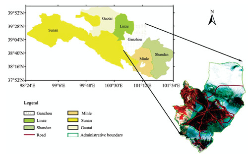
Location of the study area

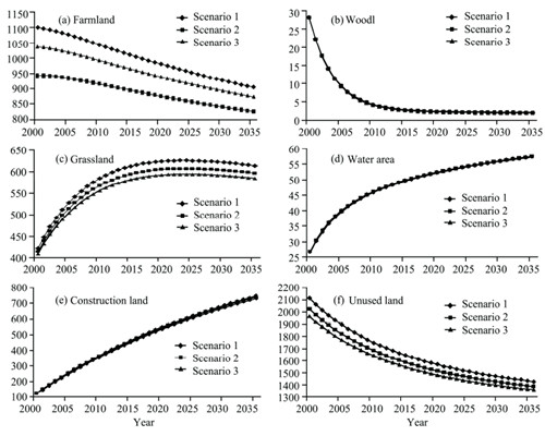
Changes of land use types in three scenarios (units: km2)

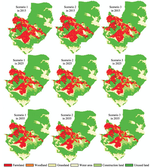
Simulated land use in study area based on three scenarios during 2015–2035
Appendix


