Englacial hydrological characteristics of a typical continental-type glacier in China as detected by ground-penetrating radar
Updatetime:2013-01-17From:
【Enlarge】【Reduce】
The englacial structures and ice thickness of the Laohugou No. 12 (L12) Glacier in the Qilian Mountains, China, were retrieved from ground-penetrating radar (GPR) profile data acquired in August of 2007. Here the interpretation of a typical GPR image is validated using two-dimensional, Finite-Difference Time-Domain (FDTD) numerical modeling. Data analyses revealed many englacial characteristics, such as temperate ice, crevasses, and cavities at the position of convergence between the eastern and western glacial branches of L12, and at an altitude between 4,600 and 4,750 m a.s.l. on the east branch. Combining ice thickness, englacial structures, subglacial topography, and surface flow velocities of this glacier, we analyzed the reasons for the distribution of temperate ice. The results show that greater englacial water content is associated with englacial crevassing and surface moulins,which allow water to be channeled to the temperate ice aquifer beneath the surface cold ice layer. Analysis of air temperature data shows that as more meltwater imports into the ice body, this has a great effect on water conservation and dynamics conditions.With climate warming, and under the influence of crevasses, subglacial structures, and ice thickness, ice thickness reduction on the L12 east branch is more rapid than that on the west branch.
GPR is very effective at revealing complex subsurface structures in extreme continental glaciers. Englacial information such as crevasses, temperatures, ice thicknesses, and glacier beds was analyzed for the causes of temperate ice. It was concluded that:
(1) We used 2D FDTD to simulate certain typical englacial information.
(2) Through GPR surveys, we obtained the ice thickness and bed landform, which will be useful for prospective research.
(3) We determined that most temperate ice is distributed near the ice bed. Although the air temperature cannot directly affect the ice body, the infiltration of meltwater can change the thermal conditions of the ice body.
(4) The characteristics of the ice body are strongly affected by thickness, surface flow velocity, crevasses, meltwater,and air temperature. Each aspect all has some effects for glacial ablation. Therefore, in the future, we need combine each aspect to treat glacier ablation.
(5) Under the influence of crevasses, subglacial structure,and ice thickness, thickness reduction on the glacial east branch is more rapid than on the west branch.

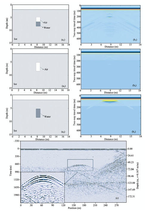
Modeling of englacial rivers with the same form and different media distribution. Modeled geometry (air mixed with water)
(a1); modeled geometry (no water) (a2); modeled geometry (saturated with water) (a3); modeled radar image (b1, b2, b3);
actual radar image (EZ segment in Figure 1, elevation between 4,613–4,657 m) (c).

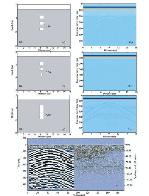
Modeling of continuous square crevasses. Modeled geometry (continuous same square crevasses) (a1); modeled geometry
(continuous difference square crevasses) (a2); modeled geometry (long square crevasses) (a3); modeled radar image (b1, b2, b3);
actual radar image (WZ segment in Figure 1, elevation between 4,550–4,650 m) (c).

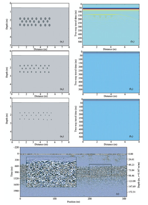
Modeling of temperate ice. Modeled geometry (water point is greater than the radar resolution) (a1); modeled geometry (water
point is less than the radar resolution) (a2); modeled geometry (large-scale water point is less than that in Figure a2) (a3);
modeled radar image (b1, b2, b3); actual radar image (HZ segment in Figure 1, elevation between 4,420–4,500 m) (c)

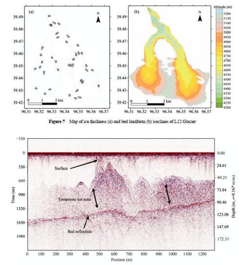
Actual radar image (including an obvious temperate ice zone) (HZ segment in Figure 1, elevation between 4,390 and 4,580 m)
Appendix


