The Experimental Study of Calculating Method of River Seepage in Middle and Upper Reaches of Heihe River Made Progress
Updatetime:2013-09-09From:
【Enlarge】【Reduce】
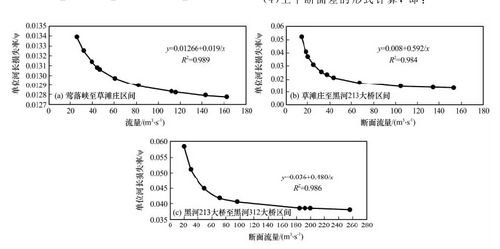
Heihe River is located in the arid region of western Gansu and Inner Mongolia, it belong to inland river basin. Scientific research personnel from CAREERI used river cross-section method. It is found that the composition of channel rock, river geometry morphological and human activities changing output and input water pattern greatly effect river seepage. River seepage remarkably changes before and after water transfer in whole basin in middle and upper reaches of Heihe River. For instance, in the sector from Yingluoxia to Bridge 312, the seepage amount was 1.2543×10⁸m3 before water transfer and is 4.3747×10⁸m3 after water transfer. The smaller the river discharge, the larger the water loss rate will be. One can see that the loss rate of unit river length of each reaches follows a reciprocal manner. This conclusion is drawn from experimental analysis by contrasting the observations in the upstream and downstream cross-sections of middle and upper reaches of Heihe River, consistent with actual situation, which can be used as basis for analyzing surface water and groundwater resources transformation in the middle and upper reaches of Heihe River, simulating groundwater flow system, and modeling repeated utilization of water resources. The conclusion also can be used to calculate seepage amount for different simulation models.
This research project provided the basic support for the transformation law research of water resources in the middle reaches of Heihe basin, groundwater flow system simulation, water resources utilization and water regulation.
This research was funded by the Open Fund Project of Heihe Key Laboratory of Ecohydrology and Integrated River Basin Science, CAREERI, CAS; Knowledge Innovation Project Major Direction (KZCX2-YW-328);Key National Natural Science Foundation of China (90702001); and National Natural Science Foundation of China (931468093).

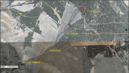
The Sketch Map of fructure suface of River Seepage Ratio Measurement in Middle and Upper Reaches of Heihe River

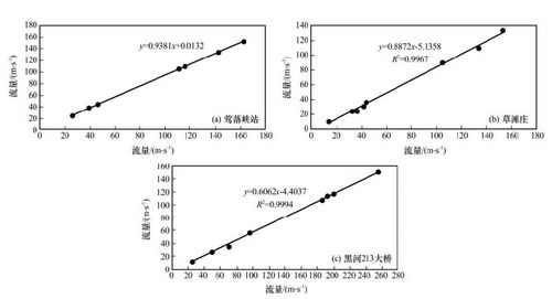
The Correlation of Fructure Surface Flow in the Upper and Lower of Each Reaches

The Relation Curve of the Different Water Discharge and the Lost Rate of Unit River in Middle and Upper Reaches of Heihe River
Appendix


