Scientists Analyze the Formative Reasons of the Yardang Landform Region in Qarhan Salt Lake
Updatetime:2013-10-15From:
【Enlarge】【Reduce】
It is generally acknowledged that the formative reasons of Yardang landform are the wind erosion, normal erosion, liner erosion and gravity collapse, etc. The research shows that wind erosion is the most important reason during the formative processes of Yardang landform. Sand drift potential (DP) is a potential maximum generated quantity within a certain period of time, also an important parameter in the dune geomorphology research, but in the study of wind erosion landforms, such as yardang landforms, there is few use it. Therefore, it is necessary to use the sand drift potential (DP) to analyze the formative reasons of Yardang landform region.
The researches on Yardang landform in China focus on the Lop Nor Region. In this paper, scientists from CAREERI (Cold and Arid Regions Environmental and Engineering Research Institute) selected the Qarhan Salt Lake as the research object, analyzed the sand drift potential (DP) in this region.
Based on the wind data collected from the automatic meteorological station installed at yardang landforms regions of the Qarhan Salt Lake, scientists analyzed the variation characteristics of wind speed, wind direction and sand drift potential. The results indicated that the monthly mean speed of sand driving wind ranges in 6.2-7.4 m•s-1, and the monthly maximum wind speed varies in 9.9-15.0 m•s-1. The sand driving wind mainly occurs in the spring and summer, the frequencies are 39.63% and 31.45%, respectively. The direction of sand driving wind is mainly WNW (West-North-West) and W (West), accounting for 41.05% and 20.02%, respectively. The annual DP and RDP (Resultant Drift Potential) is 326 VU (Vector Unit) and 235 VU, respectively, hence the studied area belongs to intermediate wind energy environment. The annual net sand transport direction is ESE (East-South-East). The wind direction variability (RDP/DP) is 0.72, belongs to intermediate radio and obtuse bimodal wind regimes. The directions of yardang bodies are basically in accordance with prevailing wind direction, so formation of yardang landform was affected mainly by wind power.
This program is financially supported by the general program of the National Natural Sciences Fund of China (41171010) and the key program of the National Natural Sciences Fund of China (41130533). The paper has been published on the Journal of Desert Research, Vol.33 No.5, Sep. 2013. Full text please see: http://zgsm.westgis.ac.cn/EN/volumn/current.shtml
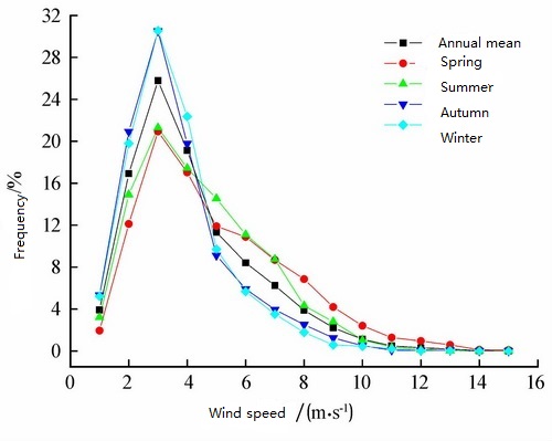
Fig.1 Wind speed frequence in the studied area (Image by CAREERI)
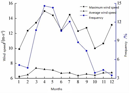
Fig.2 Change of monthly sand-driving wind speeds and their frequency (Image by CAREERI)
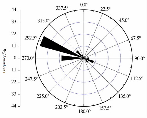
Fig.3 The annual sand-driving wind rose (Image by CAREERI)
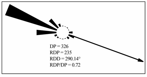
Fig.4 Sand drift rose characterized by annual drift potential (Image by CAREERI)
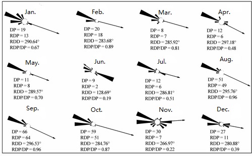
Fig.5 Variation of monthly drift potential (Image by CAREERI)
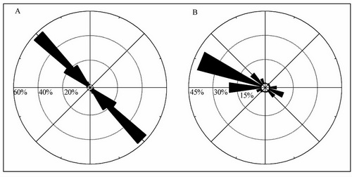
Fig.6 Probability distribution of the orientation of yardangs (A) and wind rose (B) (Image by CAREERI)
Appendix


