Scientists Found the Impact of Vegetation in Qinghai-Xizang Plateau on Summertime Precipitation in Eastern China
Updatetime:2013-11-01From:
【Enlarge】【Reduce】
Qinghai-Xizang Plateau (QXP) is located in Southwest China; its average elevation is over 4000m, and its landforms and natural landscapes are very complicated. From the rain-green forest of the southern foot of Himalayas to the desert steppe and the snowbelt of the northern foot of Himalayas, the vertical differentiation of the natural belt is very remarkable, and the distribution of vegetation is extremely uneven, so the kinds of the vegetation are various in QXP.
Plateau is the sensitive zone and ecological weak belt, so global warming has very remarkable effects on the vegetation and ecological environment of plateau. Although the distribution of vegetation is influenced by the climatic conditions, the change of vegetation will be shown through the changing for the soil moisture, surface albedo, land surface evaporation and the land surface temperature. The high elevation of plateau make effects on the middle atmosphere, so changes of the vegetation in this region and its influences should be taken more attentions.
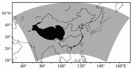
Scientists from CAREERI (Cold and Arid Regions Environmental and Engineering Research Institute) used the regional climate model (RegCM4.1-CLM3.5), simulated east Asian summer monsoon and precipitation over China during 2000 to 2009. After the examined with reanalysis data and observation records, the model was used to study the effect of vegetation over the Qinghai-Xizang Plateau on summertime precipitation in the eastern China. The result shows that the model can well reveal the averaged summer characteristics of 500 hPa geopotential height and the time evolution of western Pacific subtropical high, and it can also partly reproduce the summertime precipitation over Eastern China. However, the simulated western Pacific subtropical high seems weaker on the sea and there is also a certain deviation for the surface air temperature and precipitation. When the vegetation over the QXP changes worse, latent heating effect in the middle of troposphere above the QXP decreased obviously. Because of the zonal temperature advection, minus deviations of temperature and geopotential height are found in the upper troposphere, leading to a westward extending of south Asia high and a weakening of western Pacific subtropical high. As a result, due to the abnormal distribution of water vapor transmission of lower troposphere, precipitation in southern and northeastern China increases while that in northern China decreases.
This program is financially supported by the National Key Technology R&D Program (2007BAC29B04), “973” Program (2010CB950503), “West Doctor” of CAS and Key Laboratory of Land Surface Process and Climate Change in Cold and Arid Regions (LPCC201101). This paper has been published on the Journal of Plateau Meteorology. The full text can be seen: http://gyqx.westgis.ac.cn/EN/abstract/abstract3389.shtml

Fig. Domain area (grey area) and sensitive area (black area) in simulation experiment (Image by CAREERI)
Appendix


