Researchers Reveal the Spatiotemporal Variability of Temperature and Precipitation in Northwest China
Updatetime:2017-07-21From:
【Enlarge】【Reduce】
Gansu Province, located at the important climate transition zone in Northwest China, stretches over 1400 km from southeast to northwest. As one of the most arid areas in East Asia, Gansu Province covers multiple climate types from humid to semi-humid, and then to semi-arid and arid. Therefore, Gansu Province is often considered as being particularly vulnerable to climate change due to warming and drying.
In recent years, due to climate change and global warming, the frequency and intensity of climate extremes, such as floods, droughts and heat waves, have significantly increased in Gansu Province. Therefore, it is worthy to study the changes in climate extremes in Gansu under the background of global climate change.
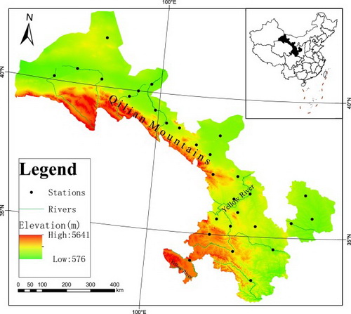
Recently, a research group headed by WEN Xiaohu from Northwest Institute of Eco-Environment and Resources of the Chinese Academy of Sciences, together with coauthors from Yantai Institute of Coastal Zone Research, has analyzed the effect of global warming on both temperature and precipitation based on the daily observation dataset at 29 meteorological stations over Gansu, and revealed the spatiotemporal variability of temperature and precipitation in Northwest China during 1951-2015.
Researchers detect monotonic trends in extreme climate indices, mean temperature and total precipitation by using the rank-based Mann-Kendall trend test, and observe the spatial variations in the annual and seasonal precipitation over Gansu. In addition, researchers also spatially grouped the 29 meteorological stations by using hierarchical clustering method, to evaluate the effect of global warming on the spatiotemporal variability of temperature and precipitation accurately in Gansu Province.
The researchers revealed that the warming trends were statistically significant at most meteorological stations in Gansu, especially at the high altitude stations, but the change trends in annual and seasonal precipitation over Gansu were not significant as expected. Furthermore, the regional-averaged temperature anomalies also showed a significant warming trend beginning at the end of 1970s. In general, precipitation increased in the western part of Gansu while decreased in the eastern part.
Additionally, the relation between large scale circulation and summer precipitation was also revealed by the wavelet analyses. Analysis of large-scale atmospheric circulation changes showed that a strengthening anticyclonic circulation, increasing geopotential height and rapid warming over the Eurasian continent were considered to be attributable to climate change in Gansu and even in Northwest China.
The results have been published in the journal Atmospheric Research in an article entitled “Spatiotemporal variability of temperature and precipitation in Gansu Province (Northwest China) during 1951-2015.”
This work was partly supported by the Youth Innovation Promotion Association, CAS (2016195), Key Research Program of Frontier Sciences of CAS (QYZDJ-SSW-DQC031), CAS Knowledge Innovation Project (KZCX2-EW-QN209), S&T Service Network Initiative (KFJ-EW-STS-127-2), and National Natural Science Foundation of China (31570423).

Map of Gansu Province showing the topography and locations of selected 29 meteorological stations (Image by WEN Xiaohu)
Contact:
WEN Xiaohu
E-mail: xhwen@lzb.ac.cn
Northwest Institute of Eco-Environment and Resources, CAS, Lanzhou, Gansu 730000, China
Appendix


