


Glaciologists use Landsat Images to Monitor Glacier Changes
Updatetime:2017-11-01From:
【Enlarge】【Reduce】
Glaciers have undergone significant changes in recent decades, and most of world’s glaciers are melting under global warming. As global climate continues to warm in the future, global glacier volume will continue to decrease.
However, there are not many effective methods and techniques to monitor and map the precise glacier changes. Therefore, how to monitor and map the glacier changes with effective tools is an important issue for glaciologist.
In recent years, Landsat satellite image are an important source of data for glaciological investigation and mapping, particularly in remote mountain regions. Due to its apparent advantages, freely available satellite data could be effectively used using an appropriate image classification technique to estimate precise glacier changes.
Recently, a research group led by KANG Shichang from the State Key Laboratory of Cryospheric Sciences, Northwest Institute of Eco-Environment and Resources of the Chinese Academy of Sciences, together with colleagues from Pakistan, collected the freely available global Landsat data using the Landsat satellite, to monitor changes in the snow-covered area of selected four glaciers in northern Pakistan.
In this study, scientists selected two frequently used techniques, namely, supervised and rule (or knowledge)-based image classification techniques. Both methods are useful and precise in terms of manual digitization, but supervised-based classification provides more consistent results and is useful for small-scale studies.
In addition, a suitable classification method for snow-covered area mapping was identified. The snow-covered areas of selected glaciers were identified and classified using supervised and rule-based image analysis techniques in three different seasons.
Furthermore, scientists also found that the supervised classification technique performed slight better than the rule-based technique by using an accuracy assessment of the classified images.
The purpose of this study is to understand the changes in snow-covered area on selected glaciers in the Karakoram region and relate these changes to changes in climate during a certain period.
The research results have been published in the Journal of Mountain Science in an article entitled “Using Landsat images to monitor changes in the snow-covered area of selected glaciers in northern Pakistan”.
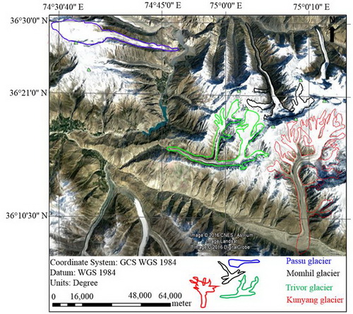
Study area map of the selected four glaciers (Image by KANG's group)
Contact:
KANG Shichang
E-mail: shichang.kang@lzb.ac.cn
State Key Laboratory of Cryosphere Science, Northwest Institute of Eco-Environment and Resources, Chinese Academy of Sciences, Lanzhou 730000, China.
Appendix
