


Scientists Evaluate the Accuracy of Two Daily-Precipitation Products over the Qinghai-Tibet Plateau
Updatetime:2019-08-16From:
【Enlarge】【Reduce】
Precipitation is an indispensable element in the study of the impact and response of climate change. High spatial and temporal resolution, wide coverage and accurate gridded precipitation data are important for climate change analysis, water resources management, hydrological forecasting, geological hazard analysis and drought monitoring.
However, high-resolution, long-term and accurate daily-precipitation are always difficult and rarely measured over the Qinghai-Tibet Plateau (QTP) because of the high altitude and complex terrain.
Recently, a research group from Northwest Institute of Eco-Environment and Resources (NIEER) of the Chinese Academy of Sciences evaluated the accuracy of two long-term satellite-based quantitative rainfall estimate products in daily scale by comparing them with 104 rain gauges over the QTP.
Scientists attempted to evaluate and compare these two precipitation datasets and they believe that this work will provide important reference for future precipitation-related research over the QTP.
The results suggest that two daily-precipitation products CHIRPS (Climate Hazards Group Infrared Precipitation with Stations data) and MSWEP (Multi-source weighted-Ensemble Precipitation) have shown great potential to be able to be applied to the precipitation-related study of the QTP.
The study shows that when compared to rain gauge observations, CHIRPS and MSWEP daily-precipitation products represent well the spatial and temporal distribution of the mean daily precipitation over the QTP, while both of them overestimate the daily-precipitation (0.18 mm/d for CHIIRPS, 0.56 mm/d for MSWEP).
Besides, both products are less accurate in dry conditions (the north QTP, winter) than in moist conditions (the south QTP, summer). Light precipitation events (0-2 mm/d) are underestimated but heavy precipitation events (2-25 mm/d) are overestimated.
Although the accuracy of MSWEP is higher than that of CHIRPS, the latter has higher spatial resolution (0.05°) and is more suitable for small-scale studies.
The study entitled “Evaluation and comparison of CHIRPS and MSWEP daily-precipitation products in the Qinghai-Tibet Plateau during the period of 1981-2015” was published in Atmospheric Research.
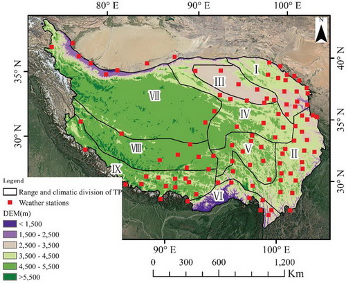
DEM of QTP and the location of nine secondary climate system of QTP, together with the distribution of 104 weather stations over QTP. (Image by SHANGGUAN Donghui)
Contact:
SHANGGUAN Donghui
E-mail: dhguan@lzb.ac.cn
State Key Laboratory of Cryosphere Sciences, Northwest Institute of Eco-Environment and Resources, Chinese Academy of Sciences, Lanzhou 730000, China.
Appendix
