


Long-Range Terrestrial Laser Scanner Assists to Reveal Glacier Mass Balances
Updatetime:2019-09-29From:
【Enlarge】【Reduce】
Tien Shan glaciers, known as the “solid reservoirs”, have experienced substantial mass loss over recent decades.
As a direct and immediate indicator of climate evolution, glacier mass balance provides important information on the gain or loss in glacier mass.
Hence, a better understanding of the relationship between Tien Shan glacier wastage and changing climate is important for projecting water availability in the near future.
Recently, a research group from Northwest Institute of Eco-Environment and Resources (NIEER) of the Chinese Academy of Sciences took Urumqi Glacier No. 1 as an example and used the long-range terrestrial laser scanner (TLS) to monitor annual and seasonal glacier mass balances for two consecutive mass-balance years (2015-2017).
The measurement data showed that Urumqi Glacier No. 1 has experienced pronounced thinning and mass loss for the four investigated periods, glacier-wide geodetic mass balance in the mass-balance year 2015-2016 was slightly more negative than in 2016-2017.
Despite uncertainties inherent in TLS-derived geodetic mass balances, the results showed that the TLS device yields reliable results and is therefore well suited to the study of Urumqi Glacier No. 1 since the observed vertical velocity component is small.
Furthermore, the TLS can provide accurate and detailed information on glacier areas and mass-balance changes, and its temporal-spatial resolution allowed more detailed insight into the glacier’s evolution.
The greatest strength of the TLS is the long-range scanning, which allowed most of the glacier surface to be measured, including areas that are inaccessible for in situ measurement.
Moreover, the TLS has application potential for glacier mass-balance monitoring in western China as most glaciers have an area smaller than one km2.
For a wide application of the long-range TLS, scientists can select some bench-mark glaciers with easily accessible locations for TLS measurements, but the presence of data voids and snow is still an enormous challenge.
The study result was published in The Cryosphere.
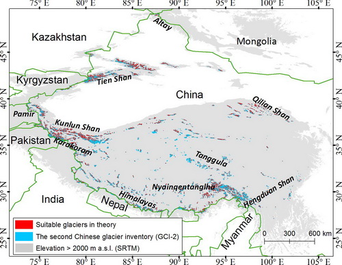
Spatial distribution of suitable glaciers: in theory those glaciers with an area of ≤1.6 km2 (approximate area of Urumqi Glacier No. 1) and a surface slope greater than 23.4°(mean slope of Urumqi Glacier No. 1) have huge potential to be monitored using the TLS. National boundary is from the ESRI. (Image by LI Zhongqin)
Contact:
LI Zhongqin
lizq@lzb.ac.cn
Tien Shan Glaciological Station, State Key Laboratory of Cryospheric Science, Northwest Institute of Eco-Environment and Resources, Chinese Academy of Sciences, Lanzhou 730000, China
Appendix
